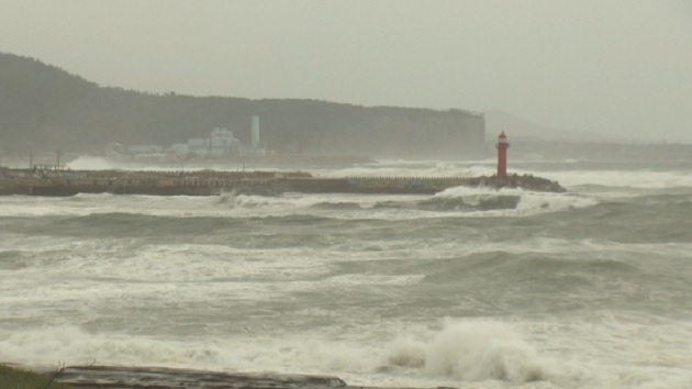
1. Typhoon Mitag brings heavy rains and gusts
Islanders need to stay up-to-date with forecasts
This year’s 18th typhoon Mitag is moving toward Jeju, and Jeju is expected to feel the effects of the typhoon from Thursday.
Typhoon Mitag has a central pressure of 970 hectopascals and a maximum wind speed of 35 meters per second. It is moving northwest at a speed of 22 kilometers per hour and it is about 270 kilometers North-Northeast (북북동) of Taipei, Taiwan.
It is expected to approach about 300 kilometers southwest-west of Seogwipo City by 9 a.m. on Wednesday.
The storm is expected to bring very strong rain of 150mm to 300mm per hour from October 1st through 3rd, and very heavy rain of more than 600mm up in mountainous areas.
The Korea Meteorological Administration (KMA) says the storm may change direction, so it is advising area residents to stay up-do-date with forecasts.
제18호 태풍 '미탁' 북상…30일부터 간접 영향
제18호 태풍 '미탁'이
세력을 키우며 제주를 향해 북상하고 있는 가운데
30일부터 간접적인 영향을 줄 것으로 보입니다.
태풍 미탁은
중심기압 975 헥토파스칼에
최대풍속이 초속 32m의 중형급 태풍으로
현재 타이완 타이베이 남남동쪽 약 410km 해상에서
시속 16km의 속도로
서북서 방향으로 이동하고 있습니다.
2일 오전 9시쯤에는
중국 상하이 남동쪽 약 90km 해상까지 접근 한 뒤
2일 밤부터 개천절 새벽 사이
가장 근접할 것으로 전망됩니다.
이에따라 제주는
1일부터 3일 사이 시간당 30~50mm의 매우 강한 비와 함께
산간에는 600mm 이상의 매우 많은 비가 예상됩니다.
기상청은
아직까지 태풍의 이동 경로가 유동적인 만큼
앞으로 발표되는 기상정보에 유의해줄 것을 당부했습니다.