1. Typhoon Mitag brings thunderstorms and gusts
Islanders need to stay up-to-date with forecasts
This year’s No.18 typhoon Mitag is moving toward Jeju, and Jeju is feeling the effects of the typhoon from Wednesday.
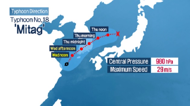
Typhoon Mitag has a central pressure of 980 hectopascals and a maximum wind speed of 29 meters per second. It passed the Shanghai and is currently moving northeast at a speed of 25 kilometers per hour.
It was the nearest to Jeju Island at 3pm on Wednesday and its impact will last through 11pm.
From early in the morning through afternoon on Wednesday, a very heavy thunderstorm showered the island through the afternoon with 256 mm of rain pouring down on Songdang-ri, Gujwa-eup, 246 mm on Seongpanak, 221 mm on Seonheul-ri, Jocheon-eup and 161 mm on Jeju City.
Some areas are being pounded with more than 50mm of rain per hour.
태풍 '미탁' 북상…2일 저녁 '최근접'
제 18호 태풍 미탁은
중심기압 980헥토파스칼에
중심부근 최대 풍속이 초속 29m인 중형급 태풍입니다.
태풍은 중국 상하이 해상을 지나
시속 25km의 속도로 북동진하고 있습니다.
2일 오후 3시 쯤
태풍이 제주에 가장 가까이 접근했으며
오후 11시까지 제주도에 직접적인 영향을 줄 것으로 예상됩니다.
.
현재 제주 전역에는 태풍특보가 발효됐습니다.
태풍의 영향으로 제주엔 새벽부터
천둥번개를 동반한 강한 비가 내렸습니다..
2일 오후까지 구좌읍 송당리에는 256mm가 넘는 물폭탄이 떨어졌고 ,
성판악 246mm, 조천읍 선흘리 221mm,
제주시 161mm 등의 강우량을 기록하고 있습니다.
특히 곳에 따라 시간당 50mm 안팎의 강한 비가 이어지고 있습니다.