1. No. 19 typhoon Hagibis is moving northward
Storm’s track remains unclear
This year’s No. 19 Typhoon Hagibis is moving northward. However, it remains unclear whether the storm will pose a danger to the Korean Penninsula.
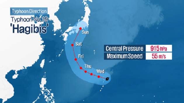
Typhoon Hagibis is a very strong medium typhoon with a central pressure of 945 hectopascals and a maximum wind speed of 45 meters per second. It has a strong wind radius of 450 kilometers and is moving West-Northwest at a speed of 26 kilometers per hour from the eastern coast of Guam.
It is expected to approach about 540 kilometers east of Okinawa, Japan by Saturday afternoon.
The Korea Meteorological Administration (KMA) says the storm is expected to head towards Kyushu, Japan, but may impact Jeju Island due to its large wind radius. Thus, it is advising area residents to stay up-do-date with forecasts.
제19호 태풍 하기비스 북상…이동 경로 촉각
제 19호 태풍 하기비스가
북상하며
이동 경로에 관심이 쏠리고 있습니다.
태풍 하기비스는
중심기압 945헥토파스칼에
중심 부근 최대풍속이 초속 45m,
강풍 반경은 400 km에 달하는
매우 강한 중형급 태풍입니다.
현재
괌 동북쪽 해상에서 시속 26 km 속도로 서북서진하고 있는데
오는 12일 오후
일본 오키나와 동쪽 약 540km 해상까지 진출할 전망입니다.
기상청은
현재로선 태풍이 일본 규슈를 향할 가능성이 크지만
세력이 워낙 강하고 강풍반경도 넓은 만큼
제주에 영향을 줄 가능성을 배제할 수 없다며
앞으로 발표되는 기상정보에 유의할 것을 당부했습니다.