‘Baengnokdam at Least 19,000 Years Old’
김민회 영어뉴스 | 1004@kctvjeju.com
| 2016.12.26 15:27
The results are in. After three months of drilling and studying, scientists have determined that the crater lake atop Hallasan Mountain is at least 19,000 years old. Minhoe Kim reports.
Report
[slug]
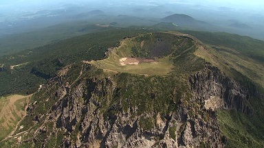
Baengnokdam at top of Hallasan
This is the crater at the top of Hallasan Mountain, called Baengnokdam.
The crater becomes a lake if there is sufficient rain, although it best shows off its grandeur when dry.
[slug]
Age of Baengnokdam disputed
Baengnokdam was undoubtedly formed through volcanism, but opinions differ as to the age of the crater, with estimates ranging from 25,000 to 70,000 years.
But three months ago, geologists, for the first time ever, drilled through the bottom of the crater lake in order to measure the age of the sedimentary layers, when volcanic eruptions took place, and the climate during various times.
[slug]
Drilling leads to ‘meaningful’ findings
Researchers extracted samples and uncovered some meaningful findings.
Scientists used radiocarbon dating and concluded that the sedimentary layers at 16 meters deep are about 14,000 years old.
At 30 meters deep, the layers are 19,000 years old.
Judging from the drilling, scientists estimate that Baengnokdam was created 19,000 or more years ago.
This means that the volcano could have erupted during the paleolithic, as the upper paleolithic dates back to between 40,000 and 10,000 years ago.
INTERVIEW
Im Jae-su / Korea Inst. of Geoscience & Mineral Resources
The results suggest that Baengnokdam is at least 19,000 years old. We got some very important data on volcanic activity and the paleoenvironment.
< 임재수 / 한국지질자원연구원 책임연구원 >
현재 우리가 바라보고 있는 백록담이 적어도 1만 9천년 전에 형성됐다, 만들어졌다는 정보를 제공하고 있고, 화산활동과 고환경연구에 있어서 굉장히 중요한 데이터를 얻었다고 할 수 있습니다.
[slug]
Topographic data collected with LIDAR
The researchers also collected topographical data for the crater and surrounding nature reserves on Hallasan Mountain with LIDAR, or Light Detection and Ranging.
That enabled them to check the topographical changes of the mountain.
INTERVIEW
Jeong Se-ho / World Heritage and Hallasan Research Center
We will be able to forecast topographic changes and erosion after five years of LIDAR monitoring. This will play a crucial role in ensuring the mountain’s stability.
< 정세호 / 세계유산본부 생물자원연구과장 >
라이다 영상을 통해서 침식, 변화되는 과정을 수치를 잡아서 한 5년 후에는 그 변화의 가늠을 알 수 있어서 안정성 보장을 위한 방안을 만드는 데 큰 역할을 할 것으로 보입니다.
[slug]
20 new species discovered
Researchers also found about 20 new species of plants and animals, including spiders and earthworms. They prove the uniqueness and biodiversity of the ecosystem on the mountain.
[Reporter] Minhoe Kim
[Camera] Kim Seong-cheol
Researchers have now wrapped up the first of a 4-year investigation to determine the age of the volcanic island. They will begin inspecting the (물장오리 오름) Muljangori-oreum wetland next year through drilling and an aerial photographic survey.
Minhoe Kim, KCTV